Saturday, December 28, 2013

Enoree Passage from Franklin Rd. to the Washed-Out Bridge on Indian Creek


Our trip on Boxing Day lasted 3 hours and 15 minutes.  We hiked 9 miles total. The trail starts out in the woods for a mile or so.  Then it hooks up with a gravel road for a good while.  You'll walk on Jalapa Road for a block or so until you get back into the woods. There were lots of hills.  It definitely wasn't an easy hike.
 About the 3rd mile into the hike, we were in a freshly trimmed part of the trail that was very prickly and full of thorns and stickers.  We couldn't decide if someone had driven a backhoe through there to cut down all the saplings on the trail, or if it was cut by a weed eater of some sort.  The sapling stumps were about 6 inches high and many were larger than a quarter inch in diameter. I was wearing jeans, but Stephanie had on sweatpants and really wished she had jeans for all scratches.

 When we got to Indian Creek, I tried to let Fred and Dixiana get a sip of water, but it was just too hard to get close enough to the water without sinking in the mud.  My feet did get wet!
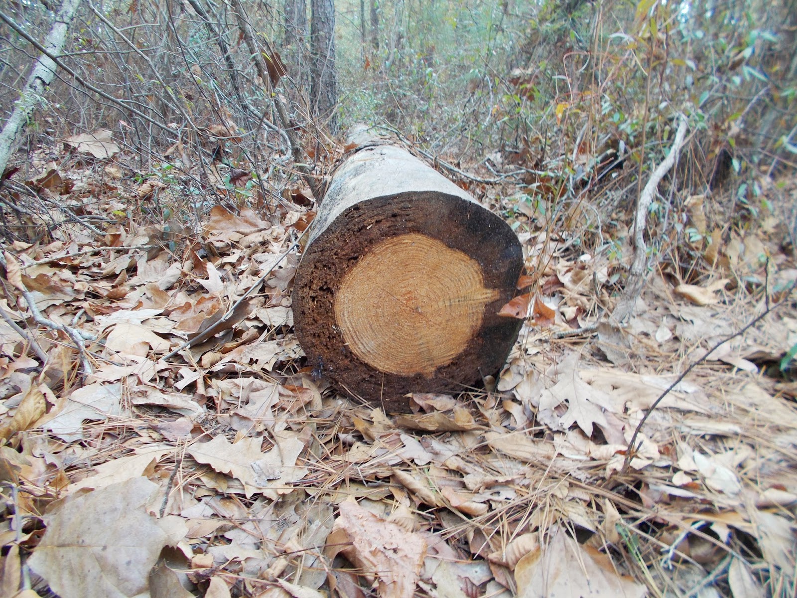
 So, the bridge was washed out.  It was a shame.  Some people have gone to a lot of work to put that bad boy in. We have had a lot of rain lately, so I wonder if the creek would be low enough to cross in drier times.  Check out the damage:


We were tired when we got to the washed out bridge--4 1/2 miles.  I had already drunk my entire water bottle and wished I'd brought another.  The way back to the car was an adventure.  We realized we would be racing against sundown again, so we picked up our pace all the way back.
For the entire 9 miles, we never met another person, cyclist, or car.
I started picking ticks off of Fred at Indian Creek, and have been picking them off both dogs for the last day or so.  I've had a few, too.
And I'm sore.  I feel like my feet are bruised. Great work out!

And now for the PRETRAIL escapades: 
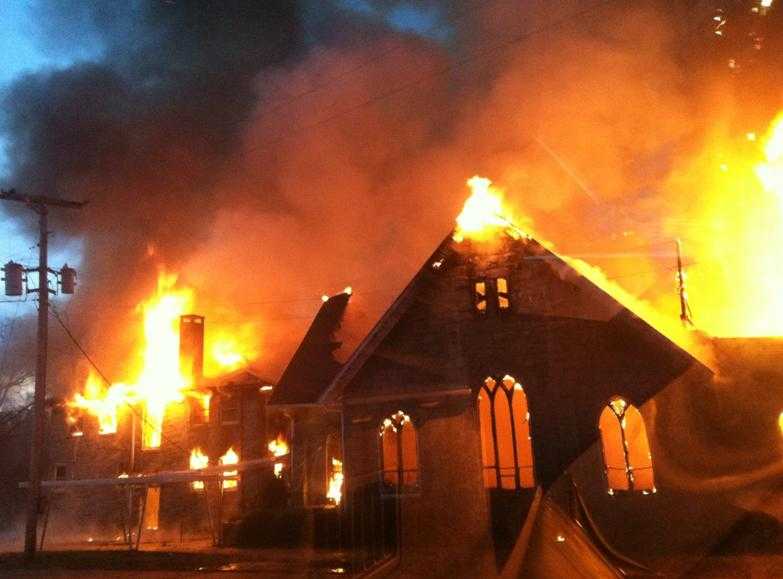
Before arriving to the Enoree Passage, Stephanie Lockhart and I made a quick stop at mile marker 82 for a restroom break.  That's when we saw this incredible burned out church!  I had to take a close up look.  It is St. Paul Lutheran Church in Pomaria, SC.
.


 Cool looking granite seat grown into the tree!
 I learned that a fire destroyed the church January 10, 2013.  Here is a picture of the fire:
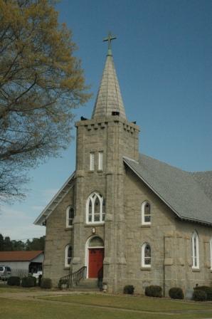
And here is what it used to look like: 
The church is the oldest Lutheran Church in Newberry County.  It is 252 years old. And this granite church structure was dedicated in 1941.

But I digress.  Moving on to the hunt for the Trailhead of the Enoree Passage of the Palmetto Trail.
Honestly, we missed it.  The directions on the Palmetto Conservation Maps give directions from Newberry and Whitmire, but not from Columbia.  I did a Google map search and followed directions to Franklin Road in Newberry County.  We followed Franklin Road from one end to the other but never saw the trail. We had to turn around a few blocks down the Old Whitmire Road onto Beth Eden Road.  And there was another church with a quaint cemetery.  We had to hop out and look around.  That's when Stephanie said, "Hey, this is where my great aunt is buried!"  What??!  Well, we found Aunt Mary's tombstone!


I loved these two side-by-side stones of Popi and Bigmama.  You know they were placed in love!

KRITTY DIRECTIONS to Franklin Road Trailhead:
If I had to give directions from Columbia, this is what I'd say:


Take I-26 to Exit 72 (about 40 minutes). Turn left on SC-121 and go 1/3 mile. Turn right on Folk Road. Go about a mile. Turn right on Old Whitmire Highway. Go about a mile.  You will pass Franklin Road, but this is ok.  Just go on down until you see Franklin Road again and turn left.  This is where it gets a little tricky.  Immediately on your right, you will see Chandler Road--and a sign for the Trail Head to the Palmetto Trail. Turn right and go down Chandler Road--a gravel road for about a mile and half to the end of the road.  Now you will be at the Trailhead!

Friday, December 27, 2013

Ft. Jackson Continued . . . Gate 5

Stephanie Lockhart and I picked up the Ft. Jackson Passage trail at Gate 5 along Leesburg Road and headed south.  We hiked 3.3 miles total (1.75 up and back) and it took 1.15 hours.
 I actually tried to take a picture of the Gate itself because it had a cute little Christmas wreath on it, but the guard came out and told me I couldn't. I wondered what Alpha level meant . . . so:
  • FPCON ALPHA describes a situation where there is a small and general terrorist threat that is not predictable. However, agencies will inform personnel that there is a possible threat and standard security procedure review is conducted. (Usually must show one or two military base IDs at gates.)
 There lots of pine saplings and foamy green moss along the tight path.  The trail winds around a lot and is very thin--one-man-wide.   Ben did find a tick on Dixie a couple of days after we got back from our hike.
Amazingly, we found a cemetery tucked away on the trail. It was pretty small.  It had lots of little infant tombstones, too. 


 I found this cute little fungus growing on the trail. I think it is called Neolecta irregularis. 


Saturday, November 30, 2013

Hope Station to Pomaria with Ben

My friend Stacy Dickinson told me that sometimes you must force your kids to go do fun things with you, even when they don't want to.  She calls it MANDATORY FUN.
So today I announced to Ben that he was going to have some mandatory fun with his mom! The dogs were so excited to be going for another walk!  Dixiana tried hard to get up into the front seat. [I had to bribe Ben with Bojangles.  The front seat smelled so much more delicious than the back.]

 My traveling buddies: Ben, Fred, and Dixiana.  I will say that Ben walked SUPER fast, and my legs and feet are sore!
 There were lots of trestles on this walk because a creek meandered through the woods.

 And hidden back here was little campsite! Wouldn't that be a fun trip?


 These old railroad signs marked our path.  Perhaps it is marking miles from Columbia up toward Greenville.


 This old brick building was the first to greet us when we reached Pomaria.


Welcome to the Pomaria Trail Head!
Hope Station to Pomaria is about 3 miles long--so we did a 6 mile walk today!


Sunday, November 24, 2013

Peak to Hope Station November 24, 2013

Peak, South Carolina over the Broad River
Stephanie Lockhart and I decided to forgo a Sunday afternoon nap for a Palmetto Trail hike!  We headed up US 176 from Columbia and on over to Alston Station via SC 213--just on the other side of the Broad River--to drop off my car at the finish line.  Then we back-tracked to Hope Station to start our hike.
 Fred and Dixiana were excited to join us on this 6.4 mile* adventure! It was in the mid 40's--chilly, but not bad.  We started about 3:00 in the afternoon.  Sundown was at 5:15 p.m., so we knew we'd need to keep a steady pace to get there with 15 minutes to spare.

 This part of the Palmetto Trail is an old railroad trail from Norfolk Southern Railroad. The part of the trail we traveled on today was first opened in 2009.
We only passed 4-5 people on our whole journey.  We thought we'd see a lot more hikers, but no.  The trees weren't in their prime, either.

 There were some sweet spots on the trail where some crafty people have made it a rustic and cozy spot to have a picnic. I wouldn't be surprised if some boy scouts had a hand in this, too.
 Just before we got to the Broad River, the little town of Peak, SC was partially visible from our trail.  It looked adorable.  I'd love to go back and visit and picnic there someday!
This is Stephanie walking Dixiana and Fred.
 Little Cabin in the Woods--just hidden in the trees on the banks of the Broad.


Stephanie and I were quite surprised when we reached the end of the Broad River at only 4 miles--instead of 6.4. Wow!  When we were about 60 yards from my car, Stephanie blurted, "Your keys are in my console!" Duh.
That's right!  I left my sunglasses and keys in her car--4 miles back.

So, we turned around, knowing it would be getting dark soon.  We made it back to her car about 5:45 pm, about 30 minutes after sundown. It was still light enough for us to see, but much farther, and we would have been walking in the dark. 8 miles round trip! The dogs did fine, too! (*When I got home, I looked up the distances to see why it was only 4 miles instead of 6.4.  There is a trail head at Pomaria, SC 2 1/2 miles up from Hope Station.  If we had started there, it would have been 6.4 miles.  And we would have been hiking in the dark. . . and in lots of pain.)